Map Scale Worksheets
- Social Studies >
- Map Skills >
- Map Scale
Scale new heights with our printable map scale worksheets that feature a set of maps with cartographic scales. Keep in mind that a scale is the ratio between a distance on the map and the corresponding distance on the ground. Actual distances or close estimates of the same can be arrived at by measuring the length on the map and multiplying it by the map scale. Use this collection and gain practice using a scale on different types of maps.
These map scale worksheets pdf are most recommended for grade 2 through grade 5 children.
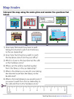
Estimating Distances on a Neighborhood Map
Watch grade 3 and grade 4 kids nimbly navigate a neighborhood, and calculate the distance between various places featured in this section of our map scale worksheets pdf.
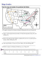
Determining Distances Using a U.S. Map
Steer 4th grade and 5th grade kids toward this printable map scale worksheet, where they are sure to have a blast estimating distances between cities marked across American states.
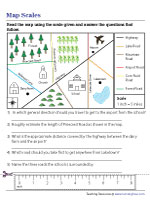
The stunning coast is on one side, wooded bliss is on the other, and a highway is in the middle of the picture depicted in this exercise on figuring out distances with a map scale.
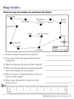
Reading a Neighborhood Map with Scale
Instruct 2nd grade and 3rd grade kids to take a brisk walk downtown on this map, using the scale to calculate the distances between different places such as the café and the library.