USA Map Worksheets
- Social Studies >
- USA Maps
Dive into our free United States maps worksheets, where the excitement of exploration meets the precision of geography. Identify lakes, rivers, mountain ranges, states, and delve into understanding the latitudes and longitudes. Warm up to the diversity of time zones and unlock the secrets of this vast and dynamic country.
These USA map worksheets pdf are recommended for grade 3, grade 4, and grade 5.
Transform this seemingly empty canvas into a dynamic learning experience by letting kids zero in on the state borders, capitals, and the vast landscapes in the United States of America.

Political Map of the USA | Blank
A visual guide for understanding the political landscape of the United States, this free map is a crucial tool in shaping 4th grade and 5th grade children's understanding of civic structure.

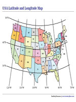
The Latitude and Longitude Grid of the USA
Use this printable resource to teach kids how to pinpoint locations with precision as they gain spatial awareness by grasping the coordinates and honing their mapping skills.
Teach kids about the Northeast, Southeast, Midwest, Southwest, and West and instill a sense of connection to different parts of the country in this part of our United States maps worksheets.

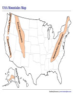
Make use of this mountain ranges map that visually showcases the locations and elevations of mountains, fostering an early appreciation for USA's diverse landscapes.
Identifying the Great Lakes in the USA
As 3rd grade and 4th grade children look at this USA lakes map and identify the majestic lakes, they’ll learn that these lakes are key players in shaping the landscape of the region.

This USA rivers map illustrates the locations, lengths, and courses of rivers, helping kids in grade 4 and grade 5 grasp the spatial relationships between different areas.

Political Map of North America
This map is a reference tool for kids studying the geography of North American and aid in memorizing locations of countries and their boundaries.

Use this outline map of North American to create assignments or quizzes where students need to label countries, cities, or physical features.

Blank Map of the Thirteen Colonies
Allow kids to trace the footsteps of early settlers, understand colonial life, and witness the formation of the nation in this section of our USA map worksheets.

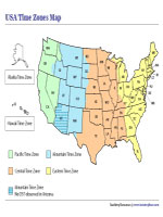
Having this map of the country's different time zones is not just about telling time, it's about understanding how the country ticks in different regions.